
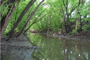
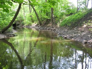
Papineau-Lavoie stream measures 8.3 km and is located on the western south end of Jesus Island. It begins in a wetland in the Joachim-Du-Belley park, upstream and merging into the Prairie River. It is known as the largest inland stream of the area. It flows through residential, industrial and commercial areas and is a keystone component of the Couvrette park in Sainte-Dorothée. There are two main sections canalized under the junction of Highway 13 and Saint-Martin boulevard and under the junction of Highway 440 and Curé-Labelle boulevard. Large sections of the stream have also been relocated which necessarily accelerated its ecological degradation in the last few years. Some portions remain quite natural and therefore hold a high conservation value and an important biodiversity restoration potential which could improve our water management approaches.
In 2013, several parameters were measured in 27 sampling stations, each distanced by 300 meters and regardless of sewage discharge, dams, retention basins. Every second sampling station, thus distanced by 600 meters, was visited once again in 2014 as a follow-up.
Results
2013 data demonstrated that the rate of degradation of Papineau-Lavoie stream is higher than expected. The 2014 data allowed to follow-up the stream’s state and compare it with other streams like Champagne, Gascon and la Pinière.
Fluvial habitat
-
Sediment levels are very high and could explain the unnatural slow flow in most sections. The stream flow is higher only in the estuary on the Prairie river (2013; 2014). Erosion was also noted downstream, at sites PAPI03, PAPI01 and PAPI25 (2014).
-
There are low levels of coarse woody debris and macrophytes in most stream sections. This brings down wildlife potentials and ecosystem health (2013; 2014).
-
The riparian buffer strip index is almost classified as high, which suggest pressures upon the entire riparian ecosystem are stronger for the drained sections than for the riparian proximity area (2013; 2014).
-
This stream has the highest proportion of waterproof and sealed surfaces in its proximity. More specifically, 41,6% of its surroundings are not permeable (2014).
-
Overall, there is an important habitat diversity in this riparian area (2014).
Water quality
-
Conductivity is extremely high, 1278,4 ± 391,4 μs/cm in 2013 and 1494,1 ± 394,1 μs/cm which means it is above the stream standard of 339 μs/cm in 96% of cases. High conductivity prevented us from doing electric fishing to describe fish communities (2013-2014).
-
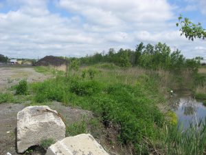
The presence of a snow deposit is preoccupying, according to our organization, because snowmelt necessarily flows into the stream (2013), bringing in high concentrations of contaminants regardless of the mitigation methods in place (see photo below).
-
Water from rain sewage systems also flows into the Papineau-Lavoie stream. The rainwater and snowmelt is actually urban runoff carrying inorganic compounds which could explain the high levels of conductivity in these waters (2013).
-
Dissolved oxygen levels are quite high considering the slow flow and degradation level of the catchment (2013). In 2014, dissolved oxygen levels were acceptable although variable throughout the sampled area (2014).
-
Recorded coliform bacteria levels were normal. However, there was a disproportionate amount of E.coli which suggests the presence of other fecal pathogenic bacteria and pollution. Stronger concentrations were recorded in residential areas which suggests potential illegal used water discharges in the stream (2013). This situation highlights the need and relevance of awareness-raising campaigns towards residents because the stream water flows into the Prairie river, which is a drinking water source for many municipalities located downstream. Such pollution involves higher water management costs and an increased health risk for thousands of people (2013).
-
Average phosphorus levels reveal a potentially concerning water quality, except during early summer periods (2014).
Biodiversity
Riparian vegetation
-
European buckthorn, common reed, purple loosestrife, reed canary grass and japanese knapweed, all of them being introduced and invasive species, were recorded in many sampling stations.
-
Endangered species such as black maple, wild ginger, bloodroot and butternut were also observed.
Benthic macroinvertebrates
-
Absence of species belonging to the Ephemeroptera, Plecoptera and Trichoptera taxa indicates a high level of stream degradation, and the high proportion on chironomids in samples reinforces this statement. Only one sensitive taxon was identified: Elmidae, which are coleoptera, were recorded in two stations PAPI07 and PAPI24) (2013).
-
In 2014, Papineau-Lavoie and Champagne streams, both in the same catchment, were recorded to have a low habitat quality and high levels of organic pollution (2014).
Ichtyological inventories
-
9 fish species of 5 different families were recorded in this stream in 2013. These species are known to be resistant to certain perturbation levels (2013).
-
Established fish populations are threatened by migration barriers and low water levels during certain periods in the summer. This also decreases the general habitability of the stream and prevents the development of more diverse fish communities.
-
Accidental catches of virile crayfish were very common (2013).
-
The most important abundance results were obtained through bait trap sampling in Papineau-Lavoie stream in 2014.
Conclusion and recommendations
Degradation levels of Papineau-Lavoie streams are very high. This stream has high sedimentation levels, low biodiversity and high levels of bacterial and inorganic (high conductivity) contamination. The stream is also fragmented. Ecosystems require connectivity and continuity in order to sustain ecological dynamics and functions. Such processes are extremely reduced in Papineau-Lavoie stream. There are however, promising conditions for a potentially successful stream restoration, given proper management actions to improve water quality, biodiversity and optimal water flow. By acknowledging the ecosystem value in urban planning, we can optimize their ecological functioning and increase collective access to their benefits.
Reports (in French)
Ecological characterization report; 2013: Rapport de caractérisation du cours d’eau Papineau-
Follow-up report; 2014: Rapport du projet Ruisseaux urbains de Laval 2014-
Media publication (in French)
March 7, 2016 –
Press releases (in French)
February 17, 2016 –
July 22, 2014 –
.jpg)
Stakeholders and special thanks
.png)
(5).png)
Thanks
We would like to thank all the stakeholders that contributed to the successful realization of this project. We would like to thank the Ministry of Natural Resources and Wildlife for sharing equipment and knowledge and for the contribution of many specialists during sampling and fish species identifications. We would also like to thank the Group for Interuniversity Research in Limnology for their expertise, sampling efforts, species identifications of benthic macroinvertebrates in their labs and for sharing equipments to measure physicochemical parameters and fecal coliforms of water samples.